Coastal Zone: Coastal Stressors
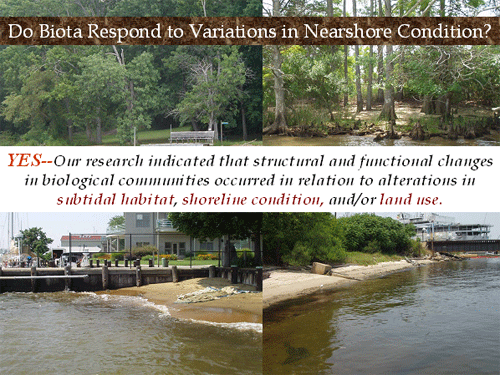
CCRM has been researching the effects of coastal stressors on nearshore habitats and biological communities for several years. These critical nearshore ecosystems serve as nursery and feeding grounds for many nekton and invertebrate species and given their proximity to upland activities, these communities may be particularly sensitive to changes in land use and developmental pressures.
Coastal Stressors include:
-
Conversion of land to commercial or residential uses.
-
Shoreline hardening and associated loss of intertidal habitat
-
Problems associated with development, such as stormwater runoff , vegetation removal, low dissolved oxygen and harmful algal blooms.
-
Degradation of ecosystems from excess nutrients, sediments and contaminants
-
Dredging or filling of important habitat.
Research Projects
1) Estuarine & Great Lakes (EaGLe) Coastal Initiative- Atlantic Slope Consortium (ASC)
 ASC was one of 5 estuarine indicator programs under the EaGLe initiative http://www.asc.psu.edu/ ASC was one of 5 estuarine indicator programs under the EaGLe initiative http://www.asc.psu.edu/
ASC Overall Goal: To develop a suite of ecological and socioeconomic indicators for assessing and managing the condition of the vital resources in the Mid-Atlantic region
The effects of land use patterns on nearshore estuarine ecosystems
One ASC Objective: To identify:

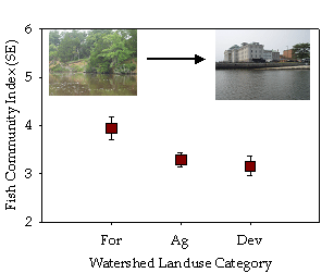
A) Objective: to examine the influence of subtidal habitat, shoreline alteration and watershed land use on nearshore fish communities in the Chesapeake Bay.
Nearshore Fish Community Responses to Habitat Condition in the Subtidal on the Shoreline and throughout the Watershed
Links
Bilkovic, D.M., C.H. Hershner, M.R. Berman, K.J. Havens and D.M. Stanhope. December 2004. Evaluating Nearshore Communities as Indicators of Ecosystem Health. Estuarine Indicators Workshop Proceedings, In: Estuarine Indicators, Stephen Bortone, ed., CRC Press, Inc., Vol. 28, 365-379. http://ccrm.vims.edu/eagles/estuarineindicators.html
http://ccrm.vims.edu/eagles/ASC_VIMS_FCIDuluth04_files/v3_slide0001.htm
B) Objective: to examine the influence of shoreline alteration and watershed land use on nearshore macrobenthic communities using established indices for related estuarine environments.
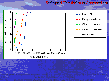
Tipping points/thresholds:Ecological thresholds mark breakpoints at which a system or community notably responds (perhaps irreversibly) to a disturbance.
 We measured the effect of developed land use on nearshore macrobenthic communities. Macrobenthic index scores decreased with anthropogenic alterations to the landscape (e.g. developed watersheds), and thresholds were identified for riparian and watershed developed land use (10-12 %) beyond which a response in macrobenthic communities is reflected in consistently low scores with reduced variability, which is indicative of stressed conditions. We measured the effect of developed land use on nearshore macrobenthic communities. Macrobenthic index scores decreased with anthropogenic alterations to the landscape (e.g. developed watersheds), and thresholds were identified for riparian and watershed developed land use (10-12 %) beyond which a response in macrobenthic communities is reflected in consistently low scores with reduced variability, which is indicative of stressed conditions.
 Negative macrobenthic community responses occurred when developed shorelines were 10% or higher. Negative macrobenthic community responses occurred when developed shorelines were 10% or higher.
Links: D.M. Bilkovic, M. Roggero, C.H. Hershner, and K. Havens. 2006. Evaluating Benthic Indices for use in nearshore estuarine habitats. Estuaries and Coasts 29(6B): 1185-1195. http://ccrm.vims.edu/pubs/ESTU2006_29_6B_1185_1195.pdf
C) Tipping points for a variety of ecological indicators in the Chesapeake Bay in relation to the amount of Developed lands
Bilkovic, D.M., other ASC researchers. Coastal development impacts on biological communities in the Chesapeake Bay- Examples from the Atlantic Slope Consortium. December 2006. Living Shorelines Summit. Bringing together diverse perspectives to address shoreline protection alternatives, Williamsburg, Virginia. Keynote speaker. (Coastal development impacts on biological communities in the Chesapeake Bay: Examples from the Atlantic Slope Consortium)
FINAL ASC REPORT: http://www.asc.psu.edu/public/pubs/_Final%20Report_AtlanticSlopeConsortium.pdf
ASC Brochure link-- “A manager’s guide to indicator selection”, published by EPA. 2006. http://es.epa.gov/ncer/publications/factsheets/mgrguidefinal41006.pdf
Summary
-
Both the amount of development and its proximity to the estuary or wetland contributes to degradation of aquatic resources.
-
In general, > 20% development (at local and/or watershed levels) was related to shifts in biological communities (indicators), revealing possible ecological thresholds
-
Forest buffers were also noted to reduce sediment and nutrient loads along stream corridors or around wetlands
-
In many instances, local development had stronger links with the aquatic resource than watershed development
Additional Products from ASC
Developing and Communicating a Taxonomy of Ecological Indicators: A Case Study from the Mid-Atlantic EcoHealth 4, 179–186, 2007. Denice Heller Wardrop, Carl Hershner, Kirk Havens, Kent Thornton, & Donna Marie Bilkovic
The Atlantic Slope Consortium (ASC) developed a taxonomy of ecological indicators to facilitate the application and evaluation of indicator selection and use, as well as the integration of appropriate indicators into environmental decision-making. The framework was based upon three primary elements: 1) The specific questions to be answered (the type of
indicator), 2) The spatial and/or temporal scale of the issue being addressed (the spatial/temporal scale over which the indicator is valid), and 3) The context of the question, using categories of surrounding land use as surrogates for social choices. A Fish Community Index (FCI) developed for the ASC will provide an example of utilizing the framework to select an indicator, as well as using the framework to judge the utility of the indicator.
http://www.springerlink.com/content/k856nq840331w401/fulltext.pdf
Assessment of Chesapeake Bay Program Selection and Use of Indicators EcoHealth 4, 187–193, 2007. Carl Hershner, Kirk Havens, Donna Marie Bilkovic, and Denice Wardrop
The utility of a taxonomy of ecological indicators developed by The Atlantic Slope Consortium (ASC) was evaluated through application within the Chesapeake Bay Program. We considered a set of 82 metrics generated by this Program, using qualitative assessment of descriptive materials. We found that 30 of these metrics conveyed sufficient information about the larger system to be considered true indicators. These 30 were classified according to the proposed taxonomy into one or more of five types: condition, evaluation, diagnostic, communication, or futures. We also evaluated the scales at which these indicators function temporally and spatially. We conclude that only a limited number of indicators are designed to be diagnostic and/or designed to forecast future conditions. The scale analyses suggest the indicator set is not
focused on local scales and/or the watershed component of the Bay system. The taxonomy succeeds in framing an assessment of existing indicator sets that can productively guide future development efforts. http://www.springerlink.com/content/d700vn2j517t4662/fulltext.pdf
2) Ecosystem approaches to aquatic health assessment: linking subtidal habitat quality, shoreline condition and estuarine fish communities Funding Source: NOAA Chesapeake Bay Office
Project goals
1) Estimate levels of development stressors at the land-water interface that elicit fish community responses
Amount of Developed Upland Land Use
Shoreline Modification (Bulkhead, Riprap, Natural)
Developed lands and Shoreline modification combinations
2) Link habitat condition monitoring datasets to support nearshore ecosystem models.
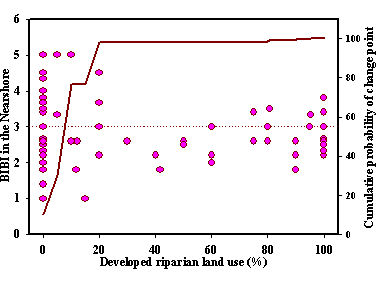
Coastal development impacts estuarine resources by severing terrestrial-aquatic linkages, reducing shallow-water habitats, and degrading ecosystem services. We assessed the effects of landscape features on nearshore habitats and biological communities, relating subtidal habitat, shoreline condition, upland land use and nearshore fish communities in a Chesapeake Bay tributary, the James River, Virginia. Both upland development and the placement of erosion control structures on the shoreline were associated with reduced fish community integrity, and shoreline alterations were linked with the amount of subtidal structural habitat in the nearshore. Ecological thresholds in nekton community integrity were evident at ≥ 23% developed land use within 200 and 1000 m buffer increments. Nekton assemblages at sites with low development (≤ 23%) and natural or riprap shorelines were different from all other combinations of altered conditions (low development with bulkhead, and high development with riprap or bulkhead). Species composition along natural or riprap revetment shorelines with low upland development tended to be diverse and inclusive of tidal marsh species, while highly developed sites or bulkhead shorelines were dominated by a few generalist species. The complex interaction between watershed (both nearshore and inland) and shoreline development presents a unique challenge for coastal planning. Alternate moderating approaches for coastal development may include preservation of riparian buffers, the placement of living shorelines for erosion control where appropriate, and development of targeting tools to identify landscapes near an ecological threshold.

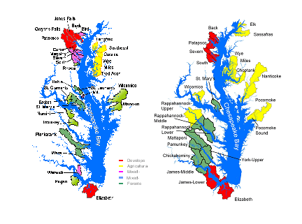
Figure 1. Fish Community Survey Locations and land use on the James River, 2005 (National Land Cover Database).

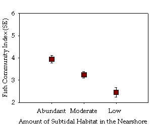
Amount of structural benthic habitat (such as oyster reefs, clam beds or woody debris) was highest at sites with natural shoreline (30%), as opposed to hardened shoreline (riprap or bulkhead; 6 %) indicating a potential land-water nexus

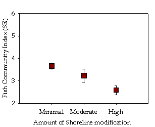
Fish Community index lowest for bulkhead sites—the most altered shorelines. Natural and riprap revetment sites similar

Established a threshold of fish community response to gradients of developed lands. Significant negative fish community response occurred at ≥23% developed lands 95% probability a threshold occurred

Species composition along natural or riprap revetment shorelines with low upland development tended to be diverse and inclusive of tidal marsh species, while highly developed sites or bulkhead shorelines were dominated by a few generalist species.
Conclusions
-
Both upland development and the placement of erosion control structures on the shoreline were associated with reduced fish community integrity.
-
Evident ecological thresholds, or breakpoints at which the fish community notably responded to a disturbance, occurred at relatively low levels of development (>23%) indicating that comprehensive shoreline and watershed land use plans are imperative to minimize impacts
-
Fish community integrity was lowest along bulkheaded shorelines, and indistinguishable between natural and riprap revetment sites, which may mimic natural shorelines.
-
The preservation of riparian zones and natural shoreline conditions, may help mitigate the stress from upland watershed development below the threshold---HOWEVER, additional research is necessary to establish what shoreline type, and/or riparian buffer type & width may be most effective in high development scenarios.
Final Report: http://ccrm.vims.edu/projreps/Bilkovic_NCBO_Final_report_May2006.pdf
Associated Publications:
Bilkovic, D.M. and M. Roggero. Effects of coastal development on nearshore estuarine nekton communities. Marine Ecology Progress Series. In Press
3) Shallow water fish communities and coastal development stressors in the Lynnhaven River(http://ccrm.vims.edu/projects/cwp/lynnhaven_fish_06/index.html)
Final Report: http://ccrm.vims.edu/shoreline_inventories/virginia/lynnhaven/lynnhaven_habitat.pdf |