Resources: York River Water Budget - Estuary Characteristics in the York River
 The York River: The York River:
1. tidal sub-estuary of the Chesapeake Bay in eastern Virginia in the United States
2. ~40 mi (64 km) long and is formed at West Point by the confluence of the Mattaponi and Pamunkey rivers with drainage to the Chesapeake Bay ~5 mi (8 km) east of Yorktown.
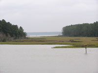
3. salinity varies from ~20 ppt at the mouth of the River to 0 ppt around West Point, and is correlated with freshwater river discharge. The river supports a wide range of habitats, from tidal freshwater marshes through salt marshes.
The Pamunkey River:
1. ~90 miles long from its start at the convergence of the North and South Anna Rivers, to its end at the town of West Point.
2. partially fed from Lake Anna Reservoir, under Virginia Power, controls its discharge rates; therefore the river flow is partially regulated. Virginia Power is required to maintain flows at a minimum of 40 cfs from the reservoir, thus the reservoir is not thought to have an impact on the hydroperiod. Downstream consumptive use has increased which has an indeterminate impact during extreme drought periods on flows.
3. primarily non-tidal north of the Rte. 360 bridge, transitioning to a tidal freshwater system at the bridge and then to a more estuarine setting south of Putney’s Mill.
4. Pamunkey watershed is dominated by forested (63.2%) and agricultural (15.3%) land use.
5. consumptive use for 1990 was estimated to average 34.2 mgd
The Mattaponi River:
1. 84 miles long, originating further up in the York River watershed at the confluence of four smaller rivers.
2. primarily non-tidal north of Aylett, transitioning to a tidal freshwater system at Aylett and then to a more estuarine setting. Flow into the York River is measured at USGS gaging stations on the two tributary rivers, located near Beulahville on the Mattaponi River and Hanover on the Pamunkey River.
3. Mattaponi watershed is dominated by forested (66.7%) and agricultural (15.2) land use.
4. consumptive use for 1990 was estimated to average 3.1 mgd in the Mattaponi River.

Living Resources in the York River
 The York River is a coastal plain estuary that drains into the Chesapeake Bay. The effect of tides is observed as far upriver as approximately 60 miles on the Mattaponi and 37 miles on the Pamunkey River. The York River is a coastal plain estuary that drains into the Chesapeake Bay. The effect of tides is observed as far upriver as approximately 60 miles on the Mattaponi and 37 miles on the Pamunkey River.
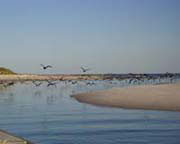
The York River also supports commercially harvested shellfish and finfish for spawning and nursery grounds as well as numerous endangered or threatened wildlife, plant and bird species.
The York River Watershed has important recreational, cultural, natural and aesthetic resources as well. Due to the relatively pristine and isolated nature of the watershed, particularly in the upper reaches, it is used extensively by recreational hunters, fishermen, photographers, cyclists and artists each year.
Two Native American tribes, the Mattaponi and Pamunkey Tribes, utilize the rivers and have the oldest reservations in the country along the riverbanks.
As recently as 1999, low flows within the Pamunkey River during consecutive years led the Virginia Power to request emergency regulatory relief from their permit water release conditions for Lake Anna. Increased water allocation and use and the potential for drought periods are significant indicators to the need for proactive water management within this watershed including preemptive drought plans that are in place prior to emergency situations. |