Resources: York River Water Budget - Geological & Sedimentary Models
 Background Background
The Mid-Atlantic states (e.g. Maryland, Virginia, North Carolina):
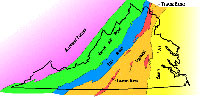
1. have 5 physiographic provinces, from west to east being the Appalachian Plateau, Valley and Ridge, Blue Ridge, Piedmont, and Coastal Plain.
2. The Atlantic Coast of the U.S. is a passive continental margin, so the Coastal Plain has gentle slopes and low relief. This topography produces meandering river systems with large sections of the rivers having tidal influence, of which the tidal freshwater reaches are a significant portion.
3. The underlying geology consists of thick deposits of well-consolidated marine sediments that thin from east to west and lap onto the crystalline rocks that underlie the Piedmont. The boundary between the Piedmont and Coastal Plain provinces is called the Fall Line and corresponds roughly with the Interstate 95 corridor.
Tidal freshwater systems are a continuum from river to estuary with linked river hydrology and geology.
Sediment sources:
1. upland erosion (land use),
2. bank erosion, and
3. input through the estuary mouth.
Sediment sinks:
1. accumulation in the channel and wetlands, and
2. loss through the estuary mouth.
Geology of tidal freshwater zone of York River
The tidal freshwater zones of the Mattaponi and Pamunkey Rivers occur from the Fall Line to just above West Point, although the USGS gaging stations are downstream of the Fall Line and are located in the tidal freshwater portion of both rivers.
Water budget of streams and rivers is determined by:
1. climate
2. topography,
3. soil type,
4. bedrock substrata,
5. groundwater discharge, and
6. vegetation.
Water is input to rivers from precipitation, surface runoff, and groundwater. Long-term groundwater withdrawal at West Point has caused measurable land subsidence and has impacted the rate of relative sea level rise in the area and possibly wetland vegetation composition.
Stream flows are affected by:
1. precipitation,
2. gradient,
3. vegetation, and
4. soil type.
Alteration to any of the factors will affect the stream hydrograph and the water’s ability to transport sediment. Stream gradient is among the most important and pervasive influences on channel form and associated vegetation. Changes in upstream flows may reduce peak flows and lessen the ability of the river to redistribute sand bars and move larger sediment particles. Storms, however, may flush and trap sediments further downstream, and hurricanes may flush sediments completely out of the system.
Sediment is deposited below Fall Line when river water enters the tidal portion and the velocity decreases. Changes in land use will affect sediment inputs by modifying vegetation, sedimentation, and erosion.
 Watershed land use has a large effect on sediment and nutrient retention in floodplains as well. Sediment is trapped in wetlands during high tides when water covers the marsh surface. This sediment input is critical for wetland health and survival. Watershed land use has a large effect on sediment and nutrient retention in floodplains as well. Sediment is trapped in wetlands during high tides when water covers the marsh surface. This sediment input is critical for wetland health and survival.
Stream banks depend on a balance between the erosive forces of flowing water and resistance of the bed, bank, and riparian (land bordering streams) vegetation. The riparian zone, often wetlands, performs numerous functions, such as moderating water temperatures, reducing sediment inputs, providing important sources of organic matter, and stabilizing stream banks.
|