Overview
Normally, the 2D model is cold-started from 0 elevation everywhere. In this case, since the model grid in the Delaware Bay covers the topography/bathymetry up to 10 meters above MSL in the watershed and up to 40 meters above MSL in the upstream Delaware River, it will take a lot of rainfall or point source inputs to raise the water level to the ground surface. To avoid this, it is preferrable to raise the initial elevation to just below the ground surface. In all setups including the ECGC setup, we recommend "eta0 = -(grid_depth)-0.1", which raise the initial water level to 0.1 m below the ground (see figure below).
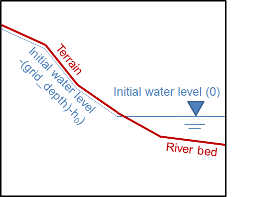
We don't recommend a smaller value than 0.1 m (e.g., 1e-6 m below ground) because such small values may generate numerical artifacts in wetting and drying due to truncation error. In some early Delaware Bay setups, a thin layer (2 cm) of water is imposed at the grid points above MSL as "eta0 = -(grid_depth)+0.02", which is not recommended unless for special purposes such as testing heavy rainfall.
Generating elev.ic
For the Delaware Bay setp, a group of scripts are provided under this folder (Elev_IC/) for automatically generating elev.ic. For the ECGC (East Coast and Gulf Coast) setup, the scripts are in schism-dev on git: $schism_git_dir/src/Utility/Pre-Processing/NWM/Elev_IC/. You can put the folder into your run directory, then do:
[your_run_dir]$ cd Elev_IC/
[your_run_dir/Elev_IC]$ ./auto.pl
This will make an elev.ic and save a copy in your run directory. You can read "auto.pl" to see what steps are involved.
■