|
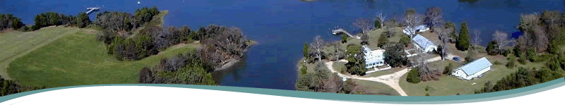
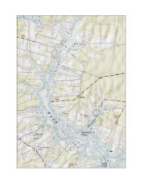
Mathews Maritime Heritage Trail: East River Trip Planning Notes
Access to the East River is limited. There are two public access points on the East River for paddlers; Town Point Landing or Williams Wharf. Both are located on the eastern side of the river and have reasonable parking but few to no facilities. Keep in mind there are no public beaches or parks to get out of your kayak along the East River. The shoreline is dominated by private property. A number of Maritime Heritage Sites can be observed from your boat, and depending on your paddling skill level, it is possible to see quite a few sites in just a few hours. Choose which direction you want to go, which side of the river you want to see, and how many segments you think you can cover. Usually one segment is all you can cover in one trip. Advanced paddlers might make it to the river entrance at Mobjack Bay and back in one trip depending on weather conditions. The East River has a north/south orientation. Plan ahead and be aware that on days when the winds blow from a northerly directions your return trip to the public landing could be a challenge.
|
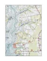
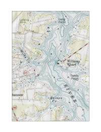
Lower East River, Eastern side: Diggs Wharf to Weston Creek
Nearest public access: |
Williams Wharf |
Distances: |
Diggs Wharf to Williams Wharf is approximately 3.5 miles. Diggs Wharf to Weston Creek is approximately 2.2 miles
|
Conditions: |
This is an exposed route. The river is wide and open to winds coming across Mobjack Bay |
Skill level: |
Advanced |
Landscape: |
Scattered homes along a mostly wooded shoreline |
Sites: |
Remains of Diggs Steamboat Wharf, Brighton/Mobjack Farm, Inn at Tabbs Creek (B&B), Woodstock, and Sutherland |
|
 |
Middle East River, Eastern side: Weston Creek to mouth of Put-in Creek
Nearest public access: |
Williams Wharf |
Distances: |
Weston Creek to Williams Wharf is approximately 1.4 miles. Weston Creek to mouth of Put-in Creek/Town Point Landing is approximately 2.7 miles
|
Conditions: |
Fairly wide open route with some wind and wave action at times |
Skill level: |
Intermediate |
Landscape: |
Dominated by Poplar Grove/Tidemill and Williams Wharf |
Sites: |
Other sites include Weston Hall, B. Williams Store, Cedar Grove, Kingston Parish/Christ Church, and Williamsdale |
|
 |
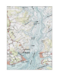
Upper East River, Eastern side: Put-in Creek
Nearest public access: |
Town Point Landing |
Distances: |
Put-in Creek is 1.5 miles long and extends to Mathews Courthouse at the headwaters. Navigation along the entire length is possible only at high tide. There is no public access at the upper end of the creek.
|
Conditions: |
Protected route. Creek is rather narrow |
Skill level: |
Beginners |
Landscape: |
Numerous older homes close to the water. Charming area |
Sites: |
Springhill, Springdale, Lanes Hotel/White Dog Inn, and Alexander James House |
|
 |
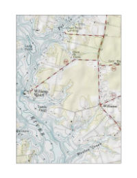
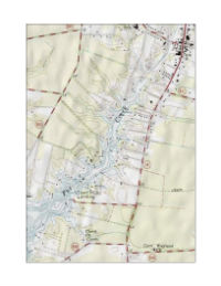
Upper East River, Western side: Long Point to the headwaters of the East River
Nearest public access: |
Town Point Landing |
Distances: |
Town Point Landing to northernmost fork in the river is approximately 4 miles
|
Conditions: |
This route is more protected than the lower East River, and the river narrows considerably to the north.
From Town Point Landing it is best to cross over to the northern shore; taking care to avoid boat traffic |
Skill level: |
Intermediate |
Landscape: |
One large creek (Woodas Creek) on eastern/northern shore. Many smaller creeks on western shore. Fun to explore there |
Sites: |
Barnum’s Point, Capt. James William Miles House, Samarkand, Pleasant View/Tynant, and Eastbrooke all on eastern/northern shore |
|
 |
Middle East River, Western side: Long Point to Raines Creek
Nearest public access: |
Williams Wharf |
Distances: |
Long Point to Raines Creek is approximately 1.7 miles
|
Conditions: |
This route is fairly exposed and can have considerable wave action when windy.
River narrows above Williams Wharf. The narrowest crossover point for this western shore segment would be at the landing. |
Skill level: |
Intermediate |
Landscape: |
Many interesting creeks to duck into when windy |
Sites: |
Hicks Wharf, Zimmerman Marine, East River Boatyard/I.K. Ward Tidemill |
|
 |
Lower East River, Western side: Raines Creek to Mobjack
Nearest public access: |
Williams Wharf |
Distances: |
Mobjack to Williams Wharf is approximately 3 miles.
Mobjack to Raines Creek is approximately 2 miles
|
Conditions: |
This is an exposed route. The river is wide and open to winds coming across Mobjack Bay |
Skill level: |
Intermediate |
Landscape: |
Open landscape area with homes concentrated within the town of Mobjack. |
Sites: |
Myrtle Grove/Davis Wharf, Compass Marina, Grace Providence Church, Town of Mobjack, and Mobjack Wharf/Philpotts Wharf |
|
|
|